Severe Thunderstorm Watch Until 10PM
SOUTHFIELD (WWJ) - The storms that are passing through the area are packing high winds and causing some damage. The National Weather Service has issued a severe thunderstorm watch, in effect for all of Southeast Michigan until 10 p.m. A "watch" means conditions are favorable for severe weather.
Severe thunderstorm warnings have also been issued in some Metro Detroit communities. Click here for the latest update.
A wind gust of 55 miles per hour was reported near Belleville. A 49 mile per hour wind gust was reported in Romulus.
Trained spotters from the National Weather Service were reporting power lines and tree limbs down in Dearborn. Several six-inch diameter tree limbs were also reported down in Livonia.
Tree limbs, about four inches in diameter were also reported down near Ypsilanti.
According to the DTE Energy outage map, more than 20,000 Southeast Michigan homes and businesses were without power due to the storms. Most, in Wayne and Washtenaw counties.
"These storms look like they're growing and capable of producing some very strong winds and hail and those are the storms that look dangerous," said AccuWeather Meteorologist Dr. Joe Sobel.
According to the National Weather Service, pea-sized hail, winds up to 50 mph, occasional cloud to ground lightning and brief heavy downpours are possible with these storms.
Metro Detroit will stay wet pretty much all week, with spotty showers and scattered storms in the forecast from now through the holiday weekend.
Here's the forecast:
Monday Afternoon: Breezy. Numerous showers and thunderstorms...large hail...and damaging winds possible. Highs 80 to 84. Southwest winds 15 to 25 mph. Chance of rain 70 percent.
Monday Night: Mostly cloudy early...then becoming partly cloudy. A chance of showers and thunderstorms through 2 am. Lows 57 to 61. Southwest winds 10 to 20 mph...diminishing to 5 to 10 mph...then turning to west late. Chance of rain 50 percent.
Tuesday: Partly sunny during the morning. Mostly cloudy during the afternoon. A chance of showers. Highs 63 to 67. Partly cloudy during the evening. Mostly clear overnight. Lows 46 to 50.
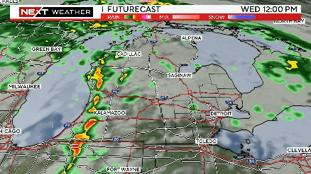
Wednesday: Mostly sunny through mid morning...then becoming mostly cloudy. A chance of showers and thunderstorms. Highs 62 to 66. Lows 53 to 57. Chance of rain 50 percent.
Thursday: Mostly cloudy. A chance of showers. Highs 62 to 66. Lows 46 to 50. Chance of rain 40 percent.
Friday: Mostly cloudy. A chance of showers. Highs 63 to 67. Lows 50 to 54. Chance of rain 30 percent.
Check out the weekend forecast at this link.
Stay ahead of the storm. Keep it tuned to WWJ Newsradio 950 for Traffic and Weather, every 10 minutes on the 8s. Check the radar now on our weather page.
Meantime, dozens have been confirmed dead following a tornado in Joplin, Missouri. Follow that coverage, including photos and video, here.