Hot Start For Labor Day Weekend Weather
DETROIT (WWJ) - It's a hot start to the Labor Day weekend, beginning with a heat advisory and an ozone action day - with temperatures expected to soar into the 90s.
The heat advisory is in effect from 11 a.m. until 8 p.m. Friday. The National Weather Service said Metro Detroit will have near record or record highs ranging from 95 to 100 degrees Friday afternoon, with heat indices hovering around 100 degrees.
The combination of hot temperatures and humidity will combine to create a situation in which heat illnesses are possible. Drink plenty of fluids, stay in an air-conditioned room, stay out of the sun and check on relatives and neighbors. Children and pets should never be left unattended in vehicles under any circumstances.
Forecast Details from the WWJ Weather Team
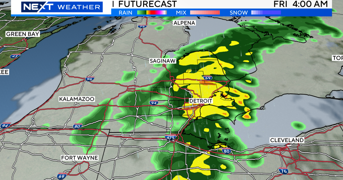
Friday - Partly sunny during the morning. Mostly sunny during the afternoon. An isolated shower or thunderstorm ending around noon. Hot and humid with highs 96 to 100. Light and variable winds becoming southwest 5 to 15 mph. Chance of precipitation 20 percent.
Friday Night - Partly cloudy. A slight chance of showers and thunderstorms. Lows 73 to 77. West winds 5 to 10 mph becoming light and variable. Chance of rain 20 percent.
Saturday - Partly sunny through mid morning then becoming mostly cloudy. A chance of showers and thunderstorms through the afternoon. Highs 91 to 95.
Light and variable winds becoming west 5 to 10 mph, then turning to south late. Chance of rain 30 percent.
Saturday Night - Mostly cloudy early then becoming partly cloudy. Showers likely with scattered thunderstorms. Lows 65 to 69. North winds 5 to 10 mph becoming light and variable. Chance of rain 70 percent.
Sunday - Partly sunny. A chance of showers with a slight chance of thunderstorms. Highs 78 to 82. West winds 5 to 10 mph. Chance of rain 30 percent.
Sunday Night - Partly cloudy during the evening. Mostly cloudy overnight. A slight chance of showers. Lows 54 to 58. Chance of rain 20 percent.
Labor Day - Partly sunny. A slight chance of showers. Highs 66 to 70. Chance of rain 20 percent.
There's no question about it, Metro Detroit has had one hot summer. The National Weather Service has been crunching the numbers and found that the summer of 2011 is the 4th warmest in history, tied with 2010. July was the hottest month ever recorded with the temps averaging almost 6 degrees above normal.
- PHOTOS: SUMMER IN MICHIGAN -
Have a photo of the hot summer weather? Send us an email.
Another record was the most consecutive days with highs of 80 or more, which was 45, from June 26th to August 9th.
Another oddity was that metro Detroit had 7 straight days of 90 plus something, and that hasn't been seen in 17 years. As for the future, autumn is supposed to be warmer than average with near normal precipitation.
For the latest, keep it tuned to WWJ Newsradio 950 for Traffic and Weather, every 10 minutes on the 8s. Visit our weather page.