Funnel Clouds Abound As Storms Move Through State
SOUTHFIELD (WWJ) - Severe weather moved across Michigan, Thursday, with funnel clouds, flooding, hail and power outages reported.
Tornado warnings issued for the area have expired, but all of Southeast Michigan remained under a severe thunderstorm watch until 11 p.m. A flash flood warning was issued for Genesee and Lapeer counties until 1:30 a.m.
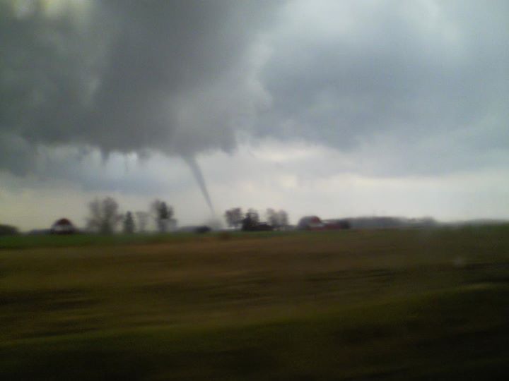
The Village of Dexter has been hardest hit, with at least one confirmed tornado sighting. Funnel cloud were also reported near Ida (see photo at right).
Mark Breckinridge, Emergency Management Director of Washtenaw County said, while limited to a small area, the quick-moving storm did significant damage in the Dexter area.
"That entire area there, near Hudson Mills Park, outside of Dexter to the north there has a lot of debris and damage to homes and downed trees and power lines," he said.
WWJ listeners said dozens of homes were damaged. At least one shed was reportedly leveled.
Breckinridge said he believes the tornado that touched down near Dexter is no longer a threat, adding that other funnels were spotted but none
were touch-downs.
Police, fire and EMS were in the Dexter area Thursday evening, combing through damaged buildings and the downed trees to make sure everyone was OK.
WWJ Newsradio 950 spoke with Mike Howey, who works at a market near Territorial and Dexter-Territorial Road.
"We saw a tornado about a couple miles from us, up on North Territorial Road. It was black and it was, you know, like going around in circles," Howey said. "We got into a building ...an underground building. "
Shad Bennett of GM Lafontaine Chevrolet Dexter in the downtown area said everyone had to hustle as they saw the twister.
He said the neighborhood directly behind the dealership had homes with portions of their roofs missing, plus a lot of stray shingles, siding and garage doors.
(See a video of the tornado on YouTube ** NOTE** Clip contains strong language)
Breckinridge reminded area residents what to do when a warning is issued or a funnel cloud is spotted.
"Go below ground if you can, and get under a sturdy object such as a table," said Breckinridge. "At a minimum you should be inside and stay away from doors and windows."
The tornado warning issued for Livingston County expired early. "We seemed to have escaped unscathed," said Livingston County Emergency Management Director Mike Kinaschuk.
He told WWJ that other than a report of a tree down in Unadilla Township, just west of Pinckney, there have been no reports of major damage.
Major flooding was reported in some areas of Ann Arbor, with feet of water creeping up on local roads.
The National Weather Service received reports of three-quarter of an inch hail near Howell and 70-mile-per-hour wind gusts were reported in Lapeer County. The Coast Guard was reporting hail accumulating on the ground in the thumb region. Earlier storms brought half-inch hail to the St. Clair Shores area.
No serious injuries or deaths were reported as of Thursday evening.
Email your storm or storm damage photos to WWJNewsroom@cbsradio.com. (By sending your photos you agree that they may appear on this website).
For the latest, keep it tuned to WWJ for traffic and weather, every 10 minutes on the 8s.
MORE: Weather Alerts - Forecast - Radar Maps - Traffic