Forecast: Severe Storms Possible
SOUTHFIELD (WWJ) - Some much warmer air is moving into Southeast Michigan and with it comes the possibility of severe, gusty thunderstorms beginning Wednesday night.
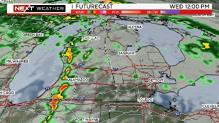
CBS 62 Chief Meteorologist Jim Madaus says with this warm front moving across the Great Lakes, Metro Detroit is becoming situated in some unstable air. Madaus says the front covers not only the entire state of Michigan, but a massive area -- stretching from the Atlantic Ocean to Washington D.C., over Detroit and Chicago all the way to central Nebraska.
According to the National Weather Service, the primary threats will be large hail up to an inch in diameter and winds as strong as 60 miles per hour. Heavy rain is also possible overnight, and, according to Madaus, anytime you have severe thunderstorms you also have a chance for a tornado or two.
Temperatures in Metro Detroit soared past 80 degrees on Wednesday. A balmy low of 63 was expected overnight.
Severe weather is also possible on Thursday, especially in the afternoon and evening, across the state. Temps are again expected to reach into the 80s.
According to Madaus, Michigan should be clear of this storm front after that.
"It's going to stay in our neighborhood on Friday but it should stay south of us," Madaus said, adding that even if Michigan does get a little wet on Friday, we should be all rained out by the end of the day, looking ahead to a dry weekend.
"The weekend's actually looking pretty good , a little cooler with some sunshine. We'll be back down into the 60s, but that's where we're supposed to be this time of year," he said.
We have our eye on the sky. Keep it tuned to WWJ Newsradio 950 for the latest forecast during traffic and weather, every 10 minutes on the 8s. For updates and live radar anytime, visit the CBS Detroit weather page.