37,000 Without Power After Storms Roll Through Southeast Michigan
DETROIT (WWJ) - A Severe Thunderstorm Watch was in effect for southeast Michigan for much of Wednesday as another storm system moved across the state.
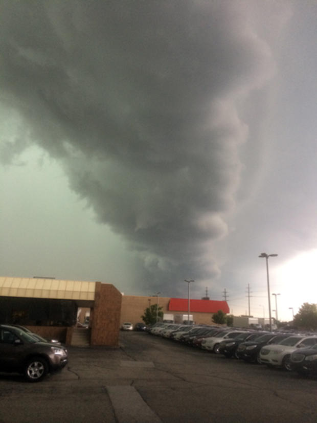
The storms that produced heavy rain, high winds and frequent lightning moved into the area as quickly.
At around 5 p.m. there were reports of a tree falling on a house on Bradley Street in Troy, near Rochester Road and East Long Lake. WWJ also received calls about power lines down along 15 Mile and Mound in Troy; and wind gusts to near 70 miles an hour were reported in Adrian. Funnel clouds were sighted at 9 Mile Road and Jefferson as well as 18 Mile and Schoenherr.
At 11 p.m. an estimated 37,000 metro Detroit homes and businesses were without power; some of them as a result of storms overnight Tuesday — and DTE Energy says additional outages were expected as more severe weather pummeled the region.
DTE spokesman Scott Simons said they're prepared for trouble.
"All of our crews know that they're going to be working 16-hour shifts around the clock to make sure our customers get back with electric service as quickly as possible," Simon told WWJ Newsradio 950's Zahra Huber.
Late in the afternoon, a DTE spokesperson said she couldn't estimate when power would be restored because many crews were taking shelter from the storms.
To report downed lines or a power outage to DTE, call 800-477-4747. You can make a report online or check the DTE outage map, HERE.
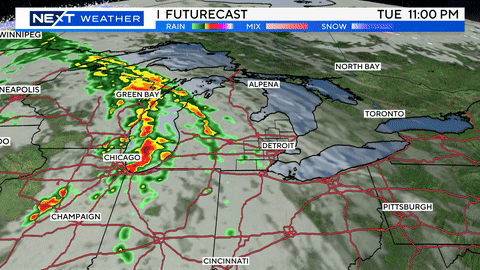
The system is moving from west to east, according to CBS 62 Chief Meteorologist Jim Madaus, and we can expect to see more "exploding storms" into the evening.
Wednesday morning, flooding caused issues on I-75 near the Southfield Freeway; and forecasters say the potential for flooding would increase Wednesday as rain continued to fall. Late Wednesday afternoon, roads were closed due to flooding in parts of Grand Blanc and Pinckney, Michigan.
Know before you go: Keep it tuned to WWJ Newsradio 950 for the latest forecast during traffic and weather, every 10 minutes on the 8s.
[Click here to see the live and local radar].
Here's the extended forecast from the CBS Detroit weather team:
Wednesday: A couple of showers and a heavy t-storm; storms can bring downpours, large hail and damaging winds. High 83.
Wednesday Night: Cloudy with a couple of showers and a thunderstorm. Low 65.
Thursday: Variable cloudiness with a shower or thunderstorm. High 82.
Thursday Night: Overcast. Low 62.
Friday: Mostly cloudy with a couple of showers and a thunderstorm. High 79.
Friday Night: Spotty showers in the evening; otherwise, mostly cloudy. Low 61.
Saturday: Variable clouds with a shower or thunderstorm around. High 80.
Saturday Night: Rather cloudy; occasional evening rain and drizzle followed by a shower in spots late. Low 63.
Sunday: Periods of clouds and sunshine with a shower or thunderstorm. High 82.
Sunday Night: A passing shower in the evening; otherwise, partly cloudy. Low 66.
Sign up for severe weather text alerts: Text STORM to 95001
For daily weather forecast text alerts: Text FORECAST to 95001