Second Wave Of Severe T-Storms Moving Through Southeast Michigan
DETROIT (WWJ) - A severe thunderstorm watch remains in effect for all of Southeast Michigan until 7 p.m. Wednesday.
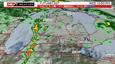
Accu-Weather's Dave Samuel says one line of storms has already moved through, but another line is heading this way.
"Setting our sites to the west - Calhoune County, Jackson County - seeing a severe thunderstorm warning at the moment. The list is all to the west of Ann Arbor - giving us a break in the short-term. More thunderstorms can be expected because the threat really doesn't end until ... around 7 p.m." said Samuel.
Any storm today could contain high winds, frequent lightning, heavy rains and hail. CHECK RADAR:
Storms have knocked out power to some portions of Romulus. About 600 customers are affected - with restoration efforts likely to continue into the evening.
The power is also out in parts of Sterling Heights - DTE crews are working to restore electricity to about 18-hundred customers. They're not sure if the outage is weather related. Power should be restored early this evening.
Customers can report an outage, check on the status of an outage, and view our outage map, all from their smart phones. Customers also may call DTE Energy at (800) 477-4747 to report power outages or downed lines. We encourage customers to use our mobile website at dteenergy.com to report a power problem using the DTE Energy Outage Center app.
Additional information on the storm – including our online Power Outage Map – available at www.dteenergy.com/outage.
Know before you go: Keep it tuned to WWJ Newsradio 950 for traffic and weather, every 10 minutes on the 8s.