We're Havin' A Heat Wave! Forecast Calls For Summery Weather Through The Holiday Weekend
DETROIT (WWJ) - Those of you who wanted hot, you got it.
AccuWeather says the temperature soared to 83 degrees Tuesday afternoon — hitting a mark we haven't reached in metro Detroit since Sept. 15 of last year.
"And we're probably not done," WWJ AccuWeather Meteorologist Dave Bowers. "We'll probably tack on another degree or two here this afternoon."
And, Bowers said, this is far from where the heat wave will end.
"We're in this kind of a summery weather pattern here for the rest of the week — middle 80s every day right on through probably the holiday weekend."
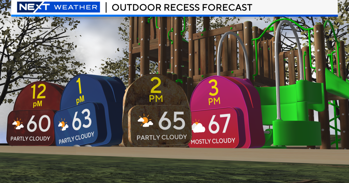
The only thing we have to watch for, Bowers said, is a spotty shower or thunderstorm here and there.
"There certainly aren't any rainy days coming," he said, "but every once in a while we may have to duck for a shower or thunderstorm, especially starting tomorrow (Wednesday) afternoon."
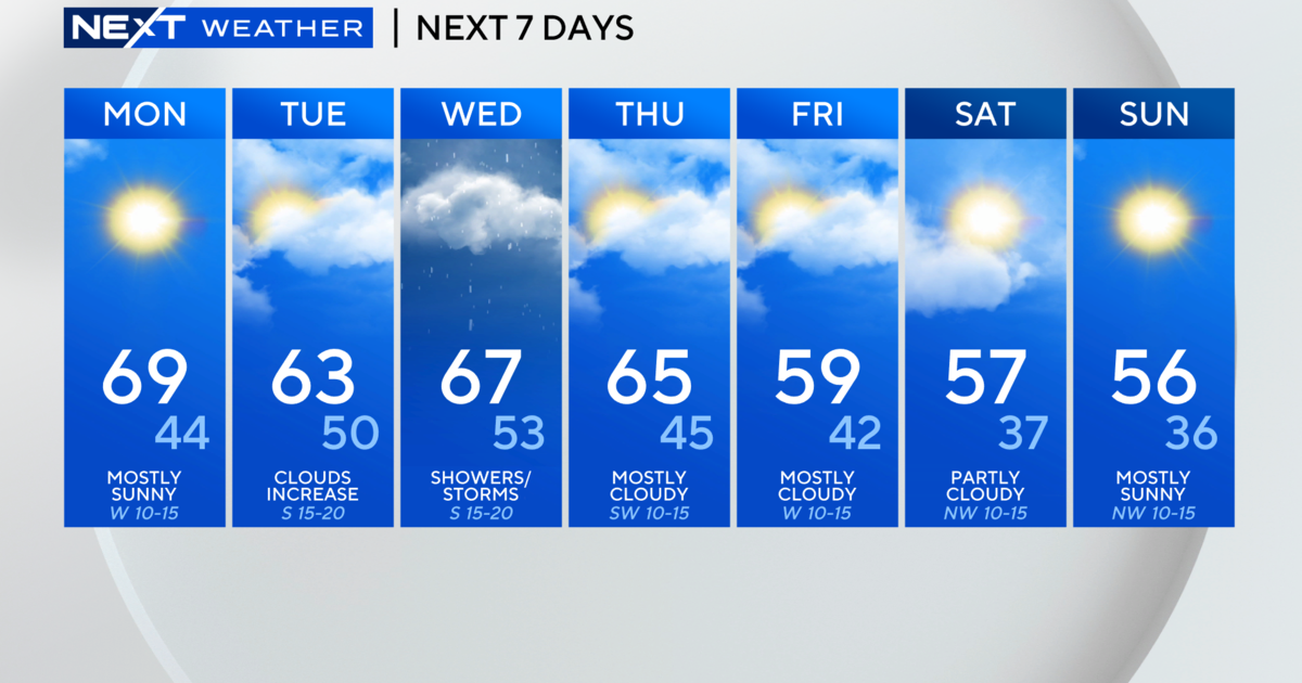
Here's the extended forecast from the CBS Detroit weather team:
Tuesday: Mostly sunny. High 89F. Winds SW at 10 to 15 mph.
Tuesday Night: Clear to partly cloudy. A stray shower or thunderstorm possible. Low 61F. Winds SW at 10 to 15 mph.
Wednesday: Partly cloudy. A stray thunderstorm is possible. High 83F. Winds SSW at 10 to 15 mph.
Wednesday Night: Partly cloudy with thunderstorms likely late. Low near 65F. Winds S at 10 to 15 mph. Chance of rain 80%.
Thursday: Scattered showers and thunderstorms. High around 85F. Winds SSW at 10 to 20 mph. Chance of rain 40%.
Thursday Night: Mostly cloudy with scattered t-storms late. Low 68F. Winds SSW at 10 to 15 mph. Chance of rain 50%
Friday: Cloudy morning with thunderstorms possible later. High 87F. Winds SSW at 10 to 15 mph. Chance of rain 80%.
Friday Night: Mostly cloudy with an evening thunderstorms. Low 68F. Winds SSW at 5 to 10 mph. Chance of rain 40%.
Saturday: Partly cloudy early with a possible afternoon thunderstorm. High 85F. Winds S at 5 to 10 mph. Chance of rain 40%.
Saturday Night: Scattered thunderstorms developing overnight. Low 67F. Winds S at 5 to 10 mph. Chance of rain 60%.
Sunday: A shower or two possible early; partly cloudy skies. High near 85F. Winds SSE at 5 to 10 mph. Chance of rain 30%.
Sunday Night: A few clouds from time to time. Low 66F. Winds light and variable.
Memorial Day: Mixed clouds and sun with scattered thunderstorms. High 84F. Winds S at 10 to 15 mph. Chance of rain 50%.
Monday Night: Isolated storms in the evening, then partly cloudy. Low 62F. Winds SSE at 5 to 10 mph. Chance of rain 30%.
For daily weather forecast text alerts: Text FORECAST to 95001