Wind Chill Warning: 'Bone-Chilling' Cold To Challenge Record Lows In Metro Detroit
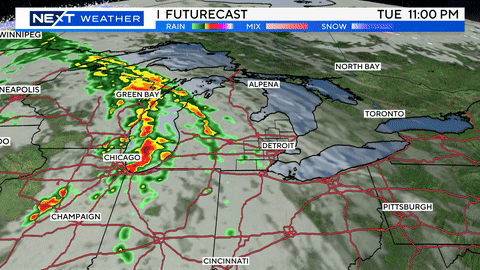
DETROIT (WWJ) - Visibility was poor at times in the roads around metro Detroit on Wednesday with snow squalls passing through — ahead of dangerously cold temperatures overnight.
AccuWeather meteorologist John Feerick says metro Detroiters should expect to see the squalls between noon and 5 p.m. — bringing an inch or two of snow accumulation, too, into the evening.
A Wind Chill Warning will be in effect beginning at 8 p.m. Wednesday through noon on Thursday for Livingston, Macomb, Oakland and St. Clair counties. A Wind Chill Advisory, meantime, has been issued for the same time period in Lenawee , Monroe, Washtenaw and Wayne.
By 11 a.m. Michigan State Police were already warning motorists to slow down and drive carefully with numerous problems on area roads due to ice and snow and whiteout conditions reported in some areas.
WWJ's Lorna Stevens said problems areas Wednesday included I-75, in both directions, between Adams and Joslin roads where a slew of spin out accidents were being reported. "Especially around Adams Road," Stevens said. "We're watching through the Triple-A jam cams, and it's just a mess in that area."
[Real Time Traffic Information]
Also, in Clinton Township motorists were asked to avoid the area Groebeck at Elisabeth where all southbound lanes were blocked due to an accident. Drivers can use Gratiot as an alternate. Along I-96 in Howell, near Pinckney, numerous spinouts were reported there as well.
Devore says that while snow showers Wednesday will bring a fresh coating to metro Detroit; but the big story will be the "bone-chilling" cold plunging in, with a high of just 19 degrees.
According to the National Weather Service, "dangerously cold" temperatures will challenge the record of 4 below zero, with a gusty winds and a real-feel temperatures as low as 30 below. Forecasters say the worst of the cold will hit between 4 a.m. and 8 a.m. — especially along and north of the M-59 corridor.
Forecasters warn that bitterly cold wind chills can lead to frost bite in 15 minutes or less and prolonged exposure to this extreme cold will lead to hypothermia.
It won't warm up much Thursday, either, Feerick said, with a high of 6 degrees and brutal real feel lows under 10 below zero before more snow comes Friday and Saturday — bringing maybe 4 additional inches to the region.
Here's the detailed forecast from the CBSDetroit weather team:
Wednesday: Variable clouds with snow showers. High 19F. Winds WNW at 10 to 20 mph. Chance of snow 50%.
Wednesday Night: Snow showers in the evening. Breaks in the overcast later. Near record low temperatures. Low -4F. Winds NW at 10 to 20 mph. Chance of snow 50%.
Thursday: Partly cloudy skies in the morning will give way to cloudy skies during the afternoon. A few flurries or snow showers possible. High 4F. Winds NW at 15 to 25 mph.
Thursday Night: Some clouds early will give way to generally clear conditions overnight. Record low temperatures expected. Low -13F. Winds WNW at 10 to 15 mph.
Friday: Except for a few afternoon clouds, mainly sunny. High 11F. Winds SW at 10 to 15 mph.
Friday Night: Occasional snow showers. Low 7F. Winds S at 10 to 15 mph. Chance of snow 50%. About 1 inch of snow expected.
Saturday: Cloudy. Snow showers developing in the afternoon. High 34F. Winds SSW at 10 to 15 mph. Chance of snow 50%.
Saturday Night: Periods of snow. Low 28F. SSE winds shifting to NE at 10 to 15 mph. Chance of snow 80%. 1 to 3 inches of snow expected.
For the latest forecast and more from the roads, stay with WWJ Newsradio 950 during Traffic and Weather on the 8s, 24-hours a day. Check live, local radar and the extended forecast HERE.