Wind Advisory: Strong Gusts, Power Outages, Downed Trees Possible
DETROIT (WWJ) - Take note if you plan to be out and about on Wednesday. The National Weather Service has issued a Wind Advisory, in effect until 10 p.m.
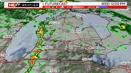
The advisory — which covers all of Southeast Michigan, including Wayne, Oakland, Macomb, St. Clair, Livingston, Washtenaw, Lenawee and Monroe counties — warns that winds will gust up to 45 mph, beginning in the afternoon into the night.
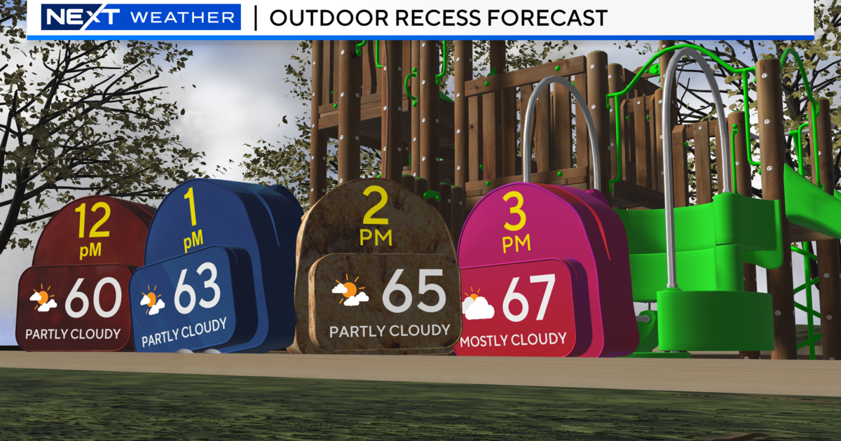
While temperatures will be up to around 60 degrees, WWJ AccuWeather Meteorologist Dean Devore says a strong cold front is on the way.
"Then some showers and thunderstorms will start to pop up again as the front that's going to bring the colder air pushes towards us around lunch time and moves over us through the afternoon," Devore said.
General Manager of the Ambassador Bridge, Randy Spader, says they've taken extra precautions, using sandbags to secure equipment on the bridge.
"Anytime you are on a bridge over a waterway you always got more winds than you do on the ground," says Spader, "but it's nothing out of the ordinary - that we are not used to or had in the past - so we just make sure everybody's aware on our staff and monitor the weather stations and keep everybody safe as they cross."
He says they monitor traffic flow and wind gusts and take appropriate measures as needed.
Downed tree limbs and localized power outages will be possible across metro Detroit, and hazardous driving conditions, especially for high-profile vehicles, are likely. Motorists are advised to exercise extra caution.
Devore says temperatures will plummet in the evening, down into the 20s overnight, and the rain will change over to snow. A couple of brisk cold days are expected, ahead of another warm-up over the weekend.
Here's the detailed forecast from the CBS Detroit weather team:
Wednesday Night: Rain and snow showers in the evening. Cloudy and windy overnight. Low around 25F. Winds WNW at 20 to 30 mph. Winds could occasionally gust up to 45 mph.
Thursday: Partly cloudy, then overcast in the afternoon. A few flurries or snow showers possible. High 38F.
Thursday Night: Partly cloudy later with any flurries or snow showers ending by midnight. Low 23F.
Friday: Partly cloudy, then overcast in the afternoon. High 34F. W
Friday Night: A few clouds. Low 19F. Winds NW at 5 to 10 mph.
Saturday: Sunshine and clouds mixed. High 37F.
Saturday Night: Partly cloudy. Low 27F.
Sunday: Sunshine and clouds mixed. High near 55F.
Sunday Night: Overcast. Low 47F.
Don't get caught in the storm. Stay tuned to WWJ Newsradio 950 for the latest severe weather updates during traffic and weather, every 10 minutes on the 8s. See the live, local radar now at this link.