Damaging Winds, Flooding A Threat With Severe Storms Expected In Metro Detroit
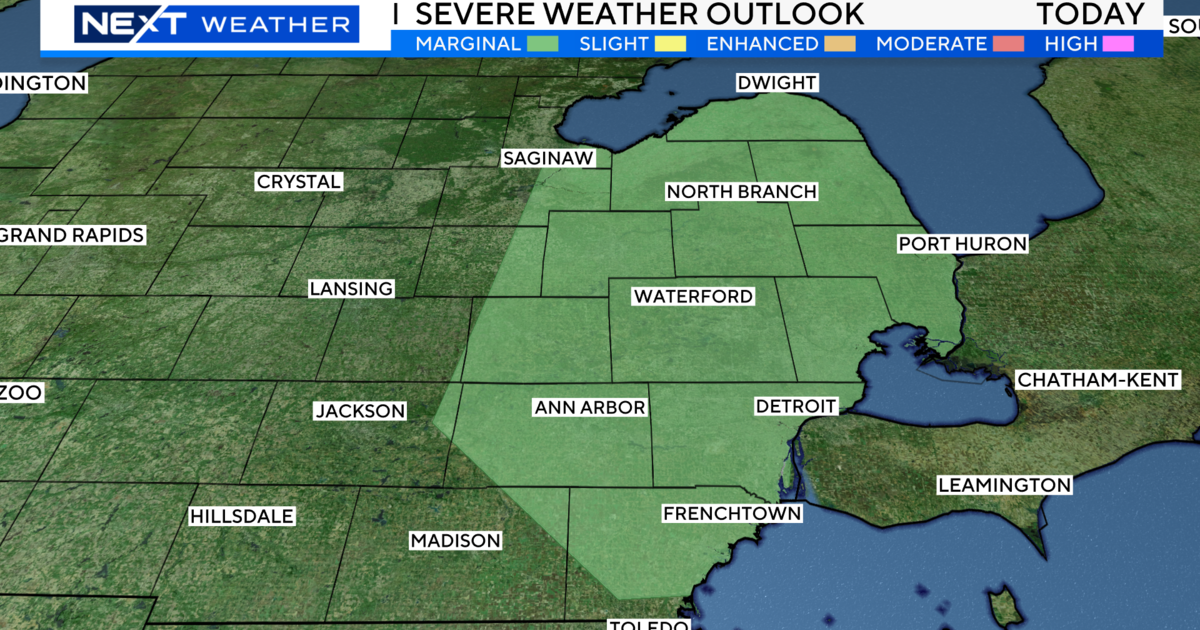
DETROIT (WWJ) - Another bout of severe weather — with heavy downpours, damaging winds, and the threat of flash-floods — is in the forecast for metro Detroit Wednesday.
A Tornado Watch was issued for Lenawee, Monroe and Hillsdale Counties until 9 p.m.; and a Flood Advisory will remain in effect for all of Southeast Michigan until 8 p.m.
AccuWeather Meteorologist Dean Devore says the heaviest storms are predicted to arrive in southeast Michigan as early as lunch time, with the worst of the weather hitting metro Detroit from 2 p.m. until as late as 10 p.m.
In an unusual move by the Detroit Public Schools, district officials announced they would send all DPS students home two hours early on Wednesday, due to the threat of severe storms. All Education Achievement Authority (EAA) Schools including charters planned to dismiss three hours early. [Check our School Closings Page].
Meantime, roughly 10,000 of the hundreds of thousands of metro Detroit homes and businesses that lost service during last weekend storms remained in the dark. A DTE spokesperson said crews hoped to get all those customers back online by Wednesday afternoon — although those efforts were expected to be hampered by yet more storms.
Lynne Chadwick, who's been without power since Friday at her home near 11 Mile and Inkster roads in Farmington Hills, wonders when she'll get service back.
"As a person without a generator, it's been a little bit of a challenge," she told WWJ's Mike Campbell. "Three days I can handle, but, more than that...I mean, they should have been able to respond quicker."
[Check the outage map HERE].
Mark Breckenridge, Director of Emergency Services and Homeland Security in Washtenaw County, says their 600 trained "Skywarn Spotters" will be ready to track whatever is coming.
"Dopplar radar is awesome. "All of the sensing data has improved in leaps and bounds over the next 20 years; but you can't replace a Skywarn spotter, because they're actually telling you what's happening on the ground," said Breckenridge. "And that's why we've trained so many of them: We believe in them very much."
At Metro Airport in Romulus, spokesman Michael Conway said extra staff has been called in in case of bad weather.
"We do have some pretty ugly stuff coming our way on radar...There's a lot of down-drafts and unpredictable wind," Conway said. "We've already made arrangements to hold public safety people, maintenance people over to help us recover from the damage."
Conway said, as for flight delays, airlines will typically wait to take off until after a thunderstorm of this magnitude. He said if you have a flight booked, call ahead.
[Check DTW flight status HERE].
High temperaturs were expected to hit the upper 70s Wednesday, before cooling down to around 60 degrees overnight. AccuWeather says Thursday and Friday will be cooler yet, with highs around 70 and lows in the 50s both days. [Check the weekend forecast HERE].
Know before you go: Keep it tuned to WWJ Newsradio 950 for the latest forecast during traffic and weather, every 10 minutes on the 8s. See the live, local radar now at this link.
Sign up for severe weather text alerts: Text STORM to 95001
For daily weather forecast text alerts: Text FORECAST to 95001
[Get storm tips from DTE, HERE].